So the eagle eyed amongst you may have noticed that A. We've now changed the title of our blog and B. We didn't actually post anything during the summer holidays, we all need a break though right?
The principal reason for the change of name is because neither of us are strictly doing a geography degree but rather degree schemes that encompass all of the Earth Sciences, this means that this blog will now be filled with Geology and Environmental Science posts as well as Geography which should make it more interesting and helpful to everyone. Now I can't remember exactly when Vix starts her course but my move in date for Lancaster is the 1st October so after freshers week I shall begin to blog regularly once again, expect a lot of climate change, edaphic topics and geological systems amongst other stuff.
I also reckon that the spike in our views this week has been Millie directing new geography students to this blog. If I were you I'd start my own geography blog, my grades improved drastically once I started writing it and I wish I'd started it in my first year. Geography went from being my worst subject at AS to my best at A2, blogging is definitely a great revision tool!
Wednesday, 7 September 2011
Wednesday, 13 July 2011
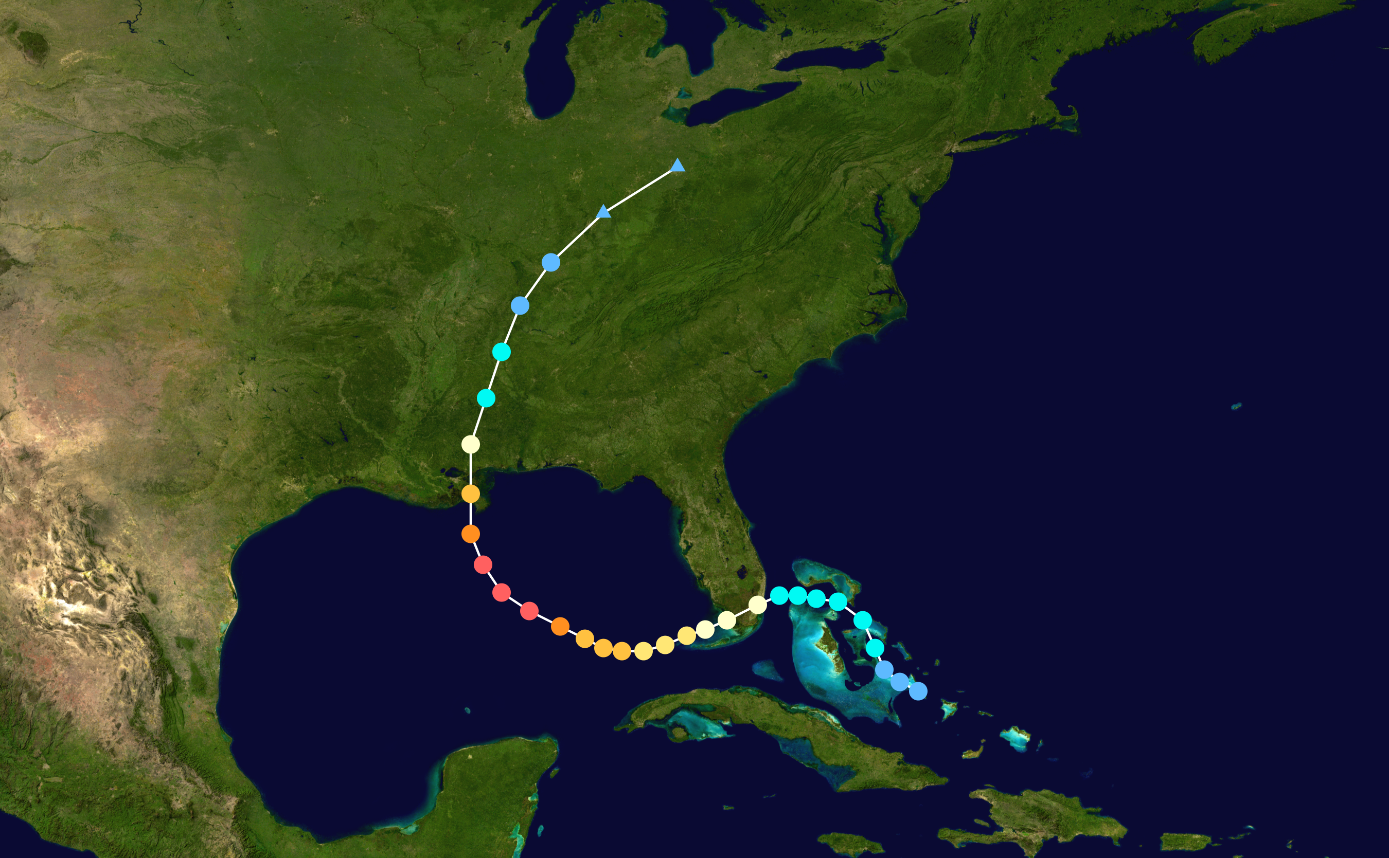
Why's East Africa heading into Famine?
Alright then lads and lasses it's been 4 weeks since I've posted anything on the blog. Four long weeks where I'm sure you checked the blog everyday with eager anticipation on what would happen now that both me and Vix have left.
So then, What has caused the (arguably) inevitable famine that's about to sweep through east Africa?
It has routes in colonialism as matters in Africa always do but overwhelmingly it's to do with the misuse of crops and the changing climate. The crops used currently by nations in Africa aren't sustainable and are based on 'western' cash crops that are used to feed the western world. This means that many of the crops don't grow to their full potential as they're not suited to the conditions this has resulted in a call for traditional crops and animals to once again be used. There was an excellent article in last months National Geographic that highlights the problems that reduced crop diversity can cause and what can be done to rectify the situation http://ngm.nationalgeographic.com/2011/07/food-ark/siebert-text. Agricultural development is also to blame for the impending famine, or a lack of it. Current technology is too expensive to be used in LDCs and the agricultural techniques themselves are also outdated. Practices such as monocultures which are used sparingly in MDCs are common practice in LDCs and are leading to reduced yields.
The changing climate happens on such a small, seemingly unnoticeable scale to anyone but scientists that the media almost never contributes it to global climate change yet it's having dire consequences on populations around the world. Current droughts in the east of Africa are being caused by a warming of the Indian Ocean due to global climate change. The impact of global climate change on rainfall patterns is clear if a quick google search is undertaken. East England, France, Russia, Australia, India, East Africa etc. have all experienced recent droughts. This when coupled with dramatically increasing populations in India and East Africa is leading to more and more famines.
What a cheery way to get back into the blog...
Wednesday, 15 June 2011
Unit 4B
I’m not actually doing the unit 4B re-sit but I thought it’d be helpful if I went through some of it. I’ve picked something that everyone should have looked into; if you haven’t then I’ve done it for you.
What does the Department for International Development do for Bangladesh?
Well according to their website the aims are to:
- Encourage private sector investment
- Ensuring the government is capable of financing and delivering social services
- Getting more children into better schools
- Improving family planning and reducing maternal deaths
These aims can be interpreted as showing that the DfID want to improve equality throughout the country to create a more stable nation. Improving equality has many positive impacts; the biggest being that it empowers women thus giving them a voice. The increased choices in life women get once empowered can lead to a reduced birth rate, which reduces the dependency ratio and creates a more manageable population. This can be seen to be working as from 2008 to 2011 the birth rate has dropped by 6 from 29 to 23 (CIA world factbook). A more manageable population is useful when trying to deal with the preparation and aftermath of a cyclone.
The DfID are also investing a lot of money into education. 25% of the £148.8 million spent in Bangladesh in 2009-2010 was spent on education. That’s £37.2 million; the amount of money spent can be linked to the development module and to South Korea who also improved education to encourage high-tech TNCs into the country. TNCs have both positive and negative (as you should have written in the exam on Tuesday!) impacts and these will also apply if TNCs move into Bangladesh.
The general aim is to create a stable developed country that can look after itself without having to rely on aid from other nations.
There are also some useful links from the website that you should probably at:
- http://www.dfid.gov.uk/Media-Room/Case-Studies/2011/Letting-girls-decide-Tackling-child-marriage-and-early-pregnancy-in-Bangladesh/ Illustrates how the DfID are helping to empower women.
- http://www.dfid.gov.uk/Media-Room/Case-Studies/2010/Sowing-the-seeds-of-scuba-rice/ This shows what can be done to reduce the agricultural impacts of cyclones and flooding.
- http://www.dfid.gov.uk/Media-Room/Case-Studies/2009/Bangladeshs-women-learn-the-art-of-flood-survival/ Shows how empowering and educating women can help to reduce the impacts of flooding.
Because I haven't been to the Unit 4B workshops I don't know what you have or haven't done, if this has been helpful then let me know and I'll do more of things like this. If it hasn't, let me know what would be helpful and I'll see if I can get round to doing it.
Tuesday, 14 June 2011
END part 2!
so james seems to have done an end blog...so i feeel i will join!
Well firstly to say this is simply the end of another geography learning step! therefore by no means is it the last of the blog, just the end of college...
Firstly, if you read this as part of Richard huish college, do you find any of it useful? If you are reading it as an AS of huish and are wondering whether or not to set up a blog for what you learn...I say do it! i wish we had started this at the beginnig of A2 and therefore had a whole years worth of work, it would have been an awesome revision source. Also if you start it now you will be revising throughout the year which has to be better than doing it all in June! Right? So yeah just do it see if you can find some more people to share the blogging with and its college, not school everyone does some weird things especially for the subjects they love, so it doesnt matter what others think!
What an idea this was, it started as a joke and seems to have now become a pretty serious thing and Millie gets way to carried away with her posts...but did we really expect anything else?
I agree with James that Millie and Nick deserve a huge thanks for the past few weeks with dealing with all our questions (and our cheek) whilst we worried about the exam, at least we are finished now and dont have to teach for 6 weeks! Oh and Millie i am most sorry if all this cake eating has caused you to put on weight and hope it hasnt involved you having to buy a whole new wardrobe!
Finally to my brilliant Geography class, you guys are pretty awesome even if some of you seem to forget that the lesson is on (yes thats right it is at the same time EVERY single week--crazy stuff!) i hope that you have enjoyed the lessons as much as we have and that even if you don't go on to do earth science you have an awesome time and may even occasionally read this.
Much love to all
End
So the exam is over. How'd everyone find it?
If you did the tectonics essay I hope the Haiti and Chile case study helped!
I don't have much to say, just thank you really. Thanks to everyone who's supported the blog, particularly our geography class and thanks to everyone who's read the posts. Thanks to both Nick and Millie for all the effort they've put in over the past couple of weeks in revision classes and having to put up with me for pretty much all of them. Especially thanks to Millie who's idea it was for this blog in the first place. I think it has started something bigger, in college anyway, where revision and extra help can be more interactive and accessible. We all know the geography facebook page is much better than moodle.
Of course most of all thanks to Vicky who's been my blog writing partner and has unrivaled enthusiasm for the subject!
If anyone has any comments about the blog, what you've found useful, what wasn't useful etc. then please could you let either me or Millie know as it'll be a great help for next years blog writers.
James
Monday, 13 June 2011
Cyclone Nargis
Cyclone Nargis
- Struck Myanmar (correct name for Burma) on 2nd May 2008
- At least 138,000 deaths. There are reports that suggest the Myanmar government stopped counting deaths after 138,000 to reduce political fallout
- Estimated damage equates to $10.2 billion (USD 2011), the most damaging cyclone in the North Indian Ocean Basin
- Most deadly cyclone in the North Indian Ocean Basin
- Highest sustained winds (1 minute) 215 km/hr. 40 km/hr more than Hurricane Katrina
- Lowest pressure was 962 mbar
- A category 4 storm is a force to be reckoned with even if you have a lot of disposable wealth and extra precautions. Myanmar has no such provisions; according to 2010 estimates (the government would never release proper figures) Myanmar are 170th for GDP PPP per capita out of a total of 194 countries. They don’t have the resources to properly protect themselves from a category 4 cyclone.
- The militant communist government that runs Myanmar is typical of militant communist governments and doesn’t like any other nation entering the country. This prevented emergency teams from helping with the recovery effort. It also prevented aid from entering the country for almost a week. Only India and Bangladesh were allowed to enter the country after this period, western countries had significant more difficulty. Western countries were only allowed in from the 23rd May onwards, 21 days after the disaster.
- The Sichuan 7.9 earthquake in China took place on the 12th May meaning that relief efforts from countries had to be halved to assist with both disasters.
- Some critics described the disaster response from the military junta as genocide; the government did little to help those in most need and thus left them to die.
How did the government respond to the disaster?
A short, simple answer would be badly but since when have I simplified things?
- Naturally the first action to take when your country has been hit by a catastrophic cyclone is to deny access to anyone who’s trying to help. As crazy as it may seem this is what the military junta did; Myanmar doesn’t have a great human rights record so they were loathe to let any other nation in as they feared that their secrets would be revealed. They did this by making it nearly impossible to acquire a visa to enter the country, the only countries allowed in were their allies; India and Bangladesh and that wasn’t for about a week. ASEAN were next to be allowed in on the 19th May and everyone else on the 23rd but no military personnel were allowed in the country.
- This resulted in a vast amount of aid from the USA and other nations being undelivered as it was transported using military ships.
- Aid was also difficult to relay to the country and the people who needed it most. In the earliest days/weeks since the disaster the only way of getting aid into the country was to send the aid to India who would then transport it to the country. This came under huge political pressure from all leaders including Gordon Brown who said that Britain wouldn’t rule out going against the military junta and conducting forced airdrops of aid into the country.
- A black-market of aid goods was also taking place within the country; in response the government said on 15th May that legal action would be taken against anyone found to be hoarding or trading in aid. By legal action I think they probably mean beating or ‘accidental death’. The corruption is illustrated when it emerged that high-energy biscuits were being stolen by the military from survivors.
- There were 5 high profile non-governmental organisations already in the country that were allowed to continue providing aid in the aftermath of cyclone Nargis. Examples are Save the Children and World Vision. Many other local NGOs switched to humanitarian efforts to mitigate the lack of recovery effort from the government.
As you can see the government didn’t really do much at all apart from to hinder the relief effort. Have some useful stats to show how little they helped:
- Over a week after the disaster only 1 in 10 survivors who were homeless, starving etc. had received assistance.
- After two weeks that had increased to about 25%
- Myanmar has vast amounts of paddies (rice growing fields) that are able to sustain its population. The UN’s Food and Agriculture Organisation predicted that Nargis affected 65% of paddies. The increased risk of famine and starvation led to Myanmar requesting assistance.
- Although aid was given much never reached the intended targets. It is estimated that 209,000 families have rebuilt their homes without assistance or aid in the last year.
Stuff to link to SPEED
S – The death toll may have been vastly under-estimated by the government to make the disaster management look better.
P – The government went ahead with the planned referendum on the 24th May despite the disaster. The fact that many people still didn’t have anywhere to live probably meant that voting figures were low.
E – The economic impacts of the disaster are much lower than that of hurricane Katrina however in proportion to the GDP of the nations it is much higher. Nargis caused just under a quarter of Myanmar’s GDP but Katrina only caused 153rd of America's GDP
E – The disruption to paddies in Myanmar could prove catastrophic to the population, causing starvation and malnutrition.
D – Due to the lack of an official census in Myanmar hazard management is much more difficult to plan for thus casualty numbers will be increased.
The last case study before the exam…
Saturday, 11 June 2011
Case Study: Hurricane Katrina
Hurricane Katrina
- Formed 23rd August 2005 and dissipated 30th August 2005. It struck New Orleans on 29th August
- Highest wind speeds were 175 mph
- Lowest pressure 902 mbar
- Worst affected area was New Orleans
- Total confirmed deaths were 1,836; only 400 of these were outside New Orleans. This makes it deadliest US hurricane since 1928.
- Total damage $90.9 billion (2011 USD)
Why was hurricane Katrina so destructive?
- The 2005 Atlantic hurricane season was abnormally active, possibly as a link to Global Climate Change warming the Atlantic ocean increasing the number and intensity of storms
- Hurricane Katrina entered the Gulf of Mexico; the Gulf of Mexico is very warm water and is effectively like giving red bull to a hurricane. The intensity of the storm increased from a category 1 hurricane (which landed in Florida) to a category 3 hurricane when it landed in New Orleans. Obviously this is going to cause more damage
- The relief effort was poorly managed (more on this later), for an MDC of America’s stature and wealth the relief should have been much more efficiently
- New Orleans is on average between 1 and 2 feet below sea level with parts of it being 7 feet below. On average only 51% of the city is at or above sea level. The problem actually is that the levees constructed to keep the water out keep the water levels above the height of the city (see the diagram to compensate for my awful description…). This means it is very easily (and was very easily) flooded, the city just fills up like a bowl. http://en.wikipedia.org/wiki/File:New_Orleans_Levee_System.svg
- Louisiana is ranked 49th in the US states for Human Development. The poorer quality of housing and education could have contributed to the large destruction. The lower affluence of the region also means that many were left without transport out of the city when the evacuation order was given.
- The storm surge extended up to 6 miles inland in some areas. By 31st August 80% of New Orleans was under water with some areas 15 feet under.

How prepared was New Orleans?
- In 2001 FEMA identified the three biggest threats on life in the USA. 1.) A major hurricane hitting New Orleans 2.) A terrorist attack on New York 3.) A large earthquake in San Francisco. Partially as a result of this the engineer corps (responsible for maintaining New Orleans levees) investigated the cost to protect South East Louisiana but decided against it, as the recurrence of a category 5 hurricane in New Orleans was 1 in 500 years. Thus is wouldn’t be economically viable to protect New Orleans.
- A simulation named Hurricane Pam was actually conducted in July 2004, which predicted the damage and destruction that would ensue from a category three hurricane striking New Orleans. The simulation highlighted several key areas that needed to be addressed to minimise casualties if a hurricane were to hit New Orleans. This website is good to read up on the hurricane Pam simulation however bare in mind that since hurricane Katrina, the response to the simulation has come under a lot of criticism so the article may be biased; http://www.globalsecurity.org/security/ops/hurricane-pam.htm
- America has arguably the best emergency response team in the world, FEMA (Federal Emergency Management Association). However in this disaster it wasn’t up to scratch, why was that? Probably because George Bush put his lawyer mate Michael Brown in charge when he had no disaster management experience, but who’s pointing fingers?
- Hurricane Cindy probably saved thousands of lives in New Orleans. Residents of city had become complacent about the risk from hurricanes meaning that when Cindy struck on 5th July 2005 few people evacuated the resulting damage forced the largest blackout in New Orleans since 1965. This scared people meaning that when hurricane Katrina was forecast more people evacuated.
How did the Government Respond?
- On the 28th August Mayor Nagin ordered a mandatory evacuation of the city, however many refused to leave due to a lack of money or the belief that their properties offered decent safety. This illustrates the lack of education about the impacts hurricanes.
- A last resort was set up for those people who didn’t leave the city; the Louisiana Superdome was supplied with ready to eat meals and bottled water but individuals were told to bring as much food and blankets as possible.
- The collapse of communication infrastructure made it difficult to organise relief efforts to relieve the many-trapped citizens who were surviving on rooftops throughout the city. In some cases reporters were asked to assist authorities in providing information about unreachable areas. By September 4th a temporary communications hub had been erected
- Only two routes remained available open out of the city and one of these was only holding emergency traffic. Fortunately New Orleans airport was relatively unscathed and opened to humanitarian flights on the 30th August and commercial cargo flights on the 10th September. Passenger flights were resumed on 13th September.
- The initial refuge of Louisiana Superdome was deemed unsafe after several roof sections were compromised and the waterproof skin on the dome was ‘peeled’ off. The governor of Louisiana evacuated the remaining people inside the stadium to the Houston Astrodome on The 30th August.
- The police force has had mixed reactions following the hurricane, they clearly played a key role in the search for survivors and also helped to control looting however many officers had ditched the city with their patrol cars before the hurricane. One resident was told to “Go to hell, it’s every man for himself” when he asked a police officer for help. It also emerged that the New Orleans police department covered up the murder of two residents by fabricating a story of being fired upon and planting a gun on the dead after the police had killed them.
- The 31st August saw the announcement that the police were now focusing on trying to control looting and violence that was hampering relief efforts. Louisiana governor Kathleen Blanco also announced that 6,500 National Guard were on their way and that “they have M-16s and are locked and loaded. These troops know how to kill and I expect they will”.
- Bush has also been criticised by foreign by foreign leaders for not accepting aid or taking a long time to respond. Interestingly some nations who you wouldn’t expect offered aid, particularly Cuba. America hates Cuba, so it’s of little surprise that they rejected the aid. Our own John Prescott was brave enough to blame the disaster on the fact that America hadn’t been participating in Kyoto.
- Bush was also criticised as it was him who had appointed Michael Brown as leader of FEMA and it had been them who the majority of blame had fallen due to the slow and poor response.
- Bush was also accused of racism, but be careful how you use this point and how you word it.
So how does this link to SPEED?
- S – It was largely the poorer populations who were worst affected as they had no transport out of the city and were stranded.
- P – Bush went on to lose the congress to the Democrats (his opposition) in the 2006 mid-term elections. The governor of Louisiana also chose not to run for a return term.
- E – The shutdown of oil platforms and refineries in the Gulf of Mexico was enough to increase oil prices.
- E – Many people suffered from mosquito related diseases such as West Nile fever and other waterborne diseases such as cholera. Interestingly it’s been proposed that the best way for New Orleans to recover in the long term is to repair wetland areas that were damaged by the hurricane as this will vastly improve fishing outputs.
- D – New Orleans is known for blues, this is something else for them to sing about. It’s also been suggested that Bush didn’t act as efficiently/quickly due to the high percentage of black population in New Orleans.
Sorry that this was so long but it’s a huge subject and I’ve cut down loads, probably to the extent that it’s missing some vital stuff but else it’d be massive. There are also a lot of other links to SPEED but I just gave a couple for each point as you should be able to figure them out. I’ll put some pictures up later but I’m now off to play a gig. Cheers for reading!
Friday, 10 June 2011
'Aquarius' salinity mapping
Today a sattelite has been sent to start orbitting our planet and map ocean surface salinity by NASA. The information gathered is going to be added to global modelling systems for global climate change. The satellite is going to measure the salinity of all ice free ocean every 7 days for the next 3 years! therefore removing inaccuracies that have occured in previous decades as this will be the first time that ocean salinity will be measured using the same method world wide. One other similar satellite (call Smos) was sent into orbit by the EU.
 The salinity will be measured by radio receivers measuring the microwave emissions being emitted from the surface; these emissions vary with the electroconductivity of water which is linked to that of how much salt is dissolved in water. The satellite is so sensitive that from one month to another it will be able to detect changes as small as 0.2 parts per thousand!
At the moment 86% of global evaporation occurs at oceans with 78% of the worlds precipitation then falls back over the oceans. therefore if these rates change then the salinity of the sea water also changes due to salt not being evaporated.
it is thought that understanding salinity is the missing link in understanding the hydrological systems. Therefore it is thought that the 3.5% salt found in oceans is just as responsible for the movement of ocean currents as the temperature alone. Salinity affects the oceans temperatures ,
The results will be very important to understanding the Thermohaline circulation in detail which is know to be caused by surface wind, tempreature and the salinity of the water (thermo= temperature and haline=salinity) where some of the water transprorted can take as long as 1600 years before it upwells!
Sunday, 5 June 2011
Revision: magma, lava, volcano shape, volcano style! and how it comes together

So there are many different types of lava type due to the plate boundary.
The thicker the area of crust that a pluton has to rise through the more enriched in silica the pluton becomes (this is all you need to know really) however, this is how it works-- so to the left is what is known as Bowen's reaction series. the basic principle is that the minerals found at the top crystalise out at higher temperatures- olivive at 1300 degrees; whereas quartz crystalises out at a much lower temperature of 550 degrees...therefore as the the pluton rises further and temperature gets relatvely cooler mafic minerals are the first to crystalise out and thus leaving a higher percentage of silica. (once cooled these are the ligher coloured rocks)
Therefore, the more silicic the magma the more explosive it is as it is sticky and viscous, this high viscocity doesnt allow easy flow therefore the pressure builds up creating some impressive eruptions(plinian,pelean,strombolian and volcanian), whereas basic magma comes directly from the aesthenosphere thus having very little distance to travel, this means very little differentiation can occur and the composition of magma is low in silica this makes for a very tame eruption (unless under an ice cap) the rocks produced are very dark in colour and the eruption less explosive (icelandic and hawaiin)
As the high ratio of silica makes the lava so very viscous the lava cannot move quickly or very far this means that very steep sided volcanoes are formed by silicic magma such as composite volcanoes, strato volcanoes and calderras (as the volcano blowing itself out happens in large explosive eruptions) whereas as shallow sided/flat volcano shapes such as shield volcanoes and fissures are caused by basaltic eruptions.
Other things to note:
-Basic volcanoes are very easy to manage and therefore areas with these attract alot of tourism.
-people live in areas with volcanoes as the soil is very fertile
-the prediction of a volcano is much easier than an earthquake
-you can try and make homes withstand the effecs of a volcano but very little with stand up to a lava flow or pyroclastics!!!
Thursday, 2 June 2011
China: A history of economic development
China: A history of economic development
If you're not interested in China's development then skip to the last paragraph which is the most relevant to the course, otherwise I apologise for the excessively long post and lack of pictures. [James]
Throughout the ancient world China was regarded as an early ‘superpower’, they were vastly more technologically developed than most (if not all) other nations. This reign of power continued all the way until 19th Century when Europe entered the Industrial revolution, leaving China struggling behind. A shadow of it’s former power and influence. The period that followed was plagued with civil war as the dynastical reign that had controlled China up until that point collapsed. The civil war ended in 1949 when the Communist party defeated the Chinese Nationalist Party (who went on to form the Republic of China).
From 1949 China became one of the strictest communist countries with harsh penalties for any capitalists often torture. Many managers of businesses committed suicide although it’s often been debated over how voluntary these deaths actually were. These campaigns were known as the three anti and five anti campaigns; they targeted capitalists and political opposition. During the years of isolation the government aimed to reduce whilst greatly investing in industrialisation to boost the economy. This period did nothing for the standard of living for the urban Chinese who had the same standard of living in 1957 up until the reforms and rural Chinese were even worse off. The standard of living was no different in 1970 than in 1930. The strict communist control did little to help China and in 1958 it suffered a terrible famine that went on to kill between 30 and 40 million. It was caused through a mixture of factors but was largely down to the fact that agricultural workers had been moved to steel manufacturing thus crops were rotting as they couldn’t be collected and the fact that Chairman Mao continued to export grain even though there was a shortage of it within China. He wanted to maintain that China had a strong image yet it was clear worldwide that people were starving within the country. After this failure Chairman Mao realised that he would take the majority of the blame so quickly jumped ship and Deng Xiaoping took leadership of China.
This marks the second phase of China’s development, 1978-1984. The first action Deng took was to increase agricultural production to prevent a repetition of the famine under Mao. This was successful and the living standards within China finally began to improve. He also made China ‘less communist’; state owned businesses were allowed to sell excess production and private businesses were once again permitted. Deng also introduced arguably the most important economic reform in China’s history and one that has had global impacts. He set up the Special Economic Zones, which allowed foreign investment and were free of bureaucracy that hampered economic growth. These areas went on to become the engines for China’s economic growth creating a growth pole for the coastal areas around them.
The period from 1984 onwards was a period of decentralisation of businesses allowing them more freedom to grow (however not as much freedom as within a capitalist country). The state sector however was still holding back the rapidly growing economy and slowing the economic development. This led to the accelerating privatisation after 1992; this led to the private sector generating a higher percentage of GDP than the state sector for the first time in the mid 90’s. The Chinese authorities recognised the increased contribution, in 1988 the private sector was said “to complement” the state sector and was then described as an “important component” in 1999. Although Deng passed away in 1997 his reforms continued under the leadership he had handpicked. This resulted in a decrease of 48% of state owned businesses between 2001 and 2004. During the same period the leadership made moves to remove the number of trade barriers, regulations and tariffs to help promote a freer movement of trade. By 2005 few companies remained state owned however the ones that did were the largest such as petroleum and banking industries.
2005 marked a turning point in Chinese economics with observers noting that the country was once again becoming more egalitarian (communist) due to conservative reformers entering the government. The state sector has been pumped full of money to encourage “national champion” businesses which can compete with global giants. Only time will tell whether this is a wise move.
What is clear that the reforms allowed and encouraged by Deng have greatly boosted China’s economy with economic growth averaging 9.5% per year from 1978 until 2005. This growth exceeded that of the Four Asian Tigers and has had dramatic effects internally and internationally. Average wages rose sixfold between 1978 and 2005 and absolute poverty declined from 41% in 1978 to 5% in 2005. The 2009 Gini coefficient report has placed China in the same category as the USA and much of South America, much higher than what it would have been ranked pre-reforms. The Chinese economy is even said to be keeping the economy of Asia afloat, the trade deficit it has with the rest of Asia is helping countries to grow and develop. It could then be said that China is the driving force behind the west’s decreasing economic power. Of course China’s growth hasn’t been without controversy, it’s regularly in the news for trying to hide something from the western world whether it’s environmental concerns, such as the three gorges dam or human rights. The day I wrote this China are in the news again being accused of trying to hack top American and South Korean accounts, although I personally feel that the North Koreans should also be investigated. The power that China now has over the world is worrying some of the western world and rightly so, but its no more power than America once held and significantly less than the British are used to. The only reason the western worlds are scared is because China isn’t an ally and the Americans are petrified of communists. Throughout history there’s often been a nation or a group of nations who have held the majority of power; the Chinese, the Romans, the Persians, the French, the British and most recently America/Europe. It appears that China and Asia are about to take that power from the western world and surely it’s only fair that power is distributed evenly over time?
I’m just looking forward to the day Africa holds the majority of the power.
Friday, 27 May 2011
The Blog
Well Vix has informed everyone what she thinks will happen to the blog so now I will.
The blog is obviously going to carry on up until the exam with (hopefully) helpful material which will (again hopefully) help people to get better grades. "What's going to happen after that though?" I hear you cry. Well I imagine that it will continue but probably with more of an emphasis on news stories and reviews and 'proper' geography in the news. Once I get to Uni the blog will probably start to become more true to it's original aim again. However the name will have to change as I'll no longer be a geography student but rather an Earth and Environmental Student and thus the posts will be catered to such an audience. I do however hope to keep it as interesting as possible despite how depressing it becomes with endless predictions of the depletion of finite resources e.g. soil (who'd have thought we'd run out of soil?!).
So yeah that's where I see this going, if it's still going after my first Uni then the blog posts will be coming to you from the delightful Iceland...
so where our blog is going
so today has been the very last day of college and this morning at 10 20 our very last ever A2 geography lesson ended. now obviously the name of the blog is what i learnt in geography this week and i am sure the name will soon change as although i am going to carry on beeing a little bit of a geography geek james is off to do environmental therefore the bredth of this blog should increase and be really accessible to all of the earth sciences.
i dont think i am going to stop blogging about random things and i am going to attempt to choose a news story each week; however i am going to wait to do this until after my exams so please still keep a watch with what is going as im sure things will be changing!
Tuesday, 17 May 2011
Comparative Case Studies: Haiti and Chile
Comparative Case Studies: Haiti and Chile
Haiti
- Date – 12th January 2010
- Magnitude – 7.0 or IX on the Modified Mercalli Scale
- Depth – 13 km (8.1 miles)
- Deaths – 92,000 t0 316,000
- 1.5 – 1.8 million homeless
Economists from Latin America estimated that the Earthquake would cost between $8.1 and $13.9 billion, almost double Haiti’s GDP of $7 billion (world bank figures for 2008).
Why was this quake so destructive?
- · Depth of the earthquake; this quake was very shallow meaning it caused more damage.
- · Haiti is an LDC and ranked 130th in GDP (nominal). This means it doesn’t have the resources or money to develop earthquake proof buildings or educate the public.
- · Haiti hadn’t experienced an earthquake in 168 years and Port-au-Prince (Haiti’s capital) hadn’t for 210 years. This lulled the Haitian people into a false sense of security.
- · Since the earthquake at least 52 aftershocks measuring magnitude 4.2 or more have been recorded. The largest (5.9) is said to have caused the collapsing of already weakened buildings.
- · Essential services were destroyed; 3 hospitals collapsed, the harbour was too damaged to be used, the control tower at the airport was seriously damaged and the main road to Jacmel (a large city in the south-east) was blocked. This prevented emergency services from helping the injured and prevented external help from reaching the country.
Government Response
- · Initial confusion over who was in charge (the government or the UN) left no single group organising relief efforts until the 16th January.
- · Government handed over control of the airport to the USA to improve flight efficiency for aid reaching the country.
- · Due to the slow distribution of resources throughout Haiti looting began to take place
- · Aid from around the world began pouring in. ICE-SAR, Iceland’s search and rescue team were the first to reach Haiti within 24 hours of the Earthquake. Teams from China, Korea, Israel and Qatar were also mobilised.
- · The USA and Canada allowed the temporary relocation of Haitians to their respected countries whilst relief efforts were underway
S – Rotting bodies were found in the streets as the Haiti government struggled to cope with the vast numbers of dead found in the streets
P – Shows globalisation between governments and how the world can pull together in times of crisis. For example the Americans were happily working alongside the Chinese and Russians something that would never have happened in the past
E – The cost of the earthquake could reach almost double that of Haiti’s GDP in 2008
E – Dead bodies were piled into cemeteries as people tried to respect the Voodoo religious burial rights however they couldn’t cope so bodies were left rotting causing disease and depression.
D – 92,000 people dead is a huge knock on the workforce of Haiti, 316,000 would be even more disastrous. At a time where the government will need all the money it can to rebuild the diminished workforce will be producing less, thus elongating the time of recovery.
Chile
- Date: 27th February 2010 (03:34 local time)
- Magnitude: 8.8 Richter scale (6th largest earthquake ever recorded). The strongest shaking reached MM IX in Concepcion, MM VII and VIII were felt in the capital Santiago
- Depth: Between 30.1 km (19 miles) and 35 km (22 miles)
- Deaths: 562 identified fatalities
- Costs: $15-30 billion worth of damage to Chile’s economy. Also caused economic impacts within other nations due to the tsunami that was caused
Geology of the Area – The Earthquake
The earthquake was a result of the Nazca plate being subducted underneath the South American plate in an Oceanic – Continental convergent boundary. Experts and seismological centres have predicted that aftershocks will continue to plague the area for up 5 years; for example on the 11th February 2011 a magnitude 6.8 aftershock struck. Chile has been capable of producing massive earthquakes since the Palaeozoic era (500 million years ago) and the largest earthquake ever recorded occurred in 1960 in Chile, magnitude 9.5.
This earthquake was 501 times more forceful than the Haiti earthquake but caused less destruction. Why was that?
- · The earthquake in Chile was at a much greater depth than that of Haiti. The Haiti earthquake was at a depth of 13km, thus almost half the depth than that of the Chile earthquake. The large depth of Chile helped to protect it from Love waves, most of which had dissipated by the time the waves had reached ground level; in comparison the shallow depth of Haiti allowed for the increased destruction due to love waves.
- · The geological history of the areas also greatly affected the earthquake; Chile is above very old rock, which is very hard thus the impact of the earthquake was reduced. In contrast Haiti sits upon very young rock, which is unconsolidated; this enhances the destruction as it means that the ground experiences more shaking and more buildings collapse.
- · Collapsing buildings are the main cause for deaths during an earthquake. Chile has stricter buildings codes than Haiti meaning that the buildings survived the earthquake better, reducing the number of fatalities.
- · The situation was lucky in some respects as the predicted wave height of the tsunami never materialized. This vastly reduced the number of fatalities that could have been expected from an earthquake of this magnitude.
- · The fact that Chile is one of the most earthquake prone countries in the world has resulted in a very educated/prepared population and emergency services. This reduced the number of fatalities of the earthquake.
Government Response
- · The government announced that it wouldn’t ask for help until it had fully assessed the situation however many nations were quick to respond e.g. the EU, the USA, China
- · To combat looting the military was ordered to assist the police and the government announced that criminal penalties would be more severe during the catastrophe. Looting quickly ends without much conflict, unlike New Orleans.
- · Countries began to send medical aid, shelters, food supplies, clothing, fuel, generators etc. Seismologists and seismology centers are also sent and set up
- · Vaccinations against tetanus and hepatitis are deployed.
- · Rubble from buildings is either re-used or sold to help with the relief effort
- · A fund was begun named Chile helps Chile with the aim of raising $29 million to build 30,000 emergency homes began on 5th March, by 23:00 on the 6th $58 million had been raised.
- · The Chilean government announces that over 35 countries responded to specific requests
The way both governments responded shows the level of preparation of Chile and how it helped to mitigate impacts. The response from the Haitian government was very ‘washy’; no singular group took charge of the relief operation for a long time, which resulted in higher numbers of casualties. Chile communicated well with other countries meaning that they got the aid they needed and where they needed it.
S – Some areas that the police/military couldn’t reach were left to fend for themselves against the looters. Some of the community armed themselves to protect their homes and/or livelihoods.
P – Shows how a government can deal with a natural disaster effectively by gathering the right type of support from around the world.
E – The Chile helps Chile fund is an excellent example of how a country can support itself during a national crisis so that it doesn’t have to rely on outside aid which may be tied or have to be repaid.
E – Research centers calculated that Santiago was moved 28cm to the southwest and Concepcion was moved at least 3m to the west.
D – The destruction caused many to be left without jobs, this could have potentially led to the negative/de- multiplier effect in some areas.
Well I hope that was helpful, it took me long enough to write.
Monday, 16 May 2011
a few development definitions:
first world:- NORMALLY DEMOCRATIC AND CAPITALIST COUNTRIES...
I.E. WESTERN EUROPE, NORTH AMERICA, JAPAN,NEW ZEALAND.
third world:- ALL OTHER COUNTRIES INCLUDING AFRICA,ASIA AND LATIN AMERICA...
-COUNTRIES THAT REMAINED NON ALIGNED
-NOT MOVING WITH CAPITALISM + NATO
I.E. COMMUNISM + SOVIET UNION
post cold war:-SOVIET UNION FELL IN 1991 , EASTERN BLOCK CEASED TO EXIST
-have now moved away from purely economic and political indicators
the Brandt line- north/south divide
(now considered derogatory-- Indonesia and south America both above the line)
GDP-total value of products and services produced within the territorial boundary of a country
-used to seee how the strength of a countries local economy
GNP-total value of goods and services produced by all nationals of acountry (whether living in or out the country)
-used to see how the nationals of the country are doing economically
HDI-a measurement of gnp/capita, adult literacy, school enrolement, le at birth
- number produced is between 0 and 1
- 1-0.8 = high
-0.8-0.6= medium
- below 0.6 = low
the environment can hold hdi backwhereas economy can boost it
HPI-shows ecological efficiency
-high levels of resource consumption do not rely produce high levels of well being
CORE PERIPHERY
- the fact that there can be variation in a country
e.g. USA-washington HDI= high.
- vancouver and seattle just over the border= tourists
WHEREAS
-montana HDI=low
-near mountains
-new orleans HDI=low
extreme weather; hurricanes etc
MDC-stable economy high GDP and HDI
NIC's- S.Korea- more than 40years
RIC's- last 40years i.e India
LDC- (see previous post)
CPE's- communist countries N.Korea, China, Kerela, Cuba, Vietnam, Burma
ORC's-oil rich countries -some developed some not
DEVELOPMENT IS A CONTINUAL PROCESS!!!!!
Sunday, 17 April 2011
Revision - Tectonics
Apparently our exams are coming up? I don't really know, I think Millie said something about doing 7 hours of revision a week. That sounds a bit extensive to me, I'll give it a few more weeks until I start...
So I am going to start delving back into my favourite topic and prove my nerdiness to the world as I get excited by the Laki eruption of 1783 (and the synoptic links it offers), the Wilson cycle, the possibility of predicting earthquakes etc. I'm like a child before christmas.
The first topic shall be... (drum roll)
THE EVIDENCE FOR CONTINENTAL DRIFT AND IT'S RELATIVE USEFULNESS
So alrighty then, lets get this show on the road. Firstly what is continental drift? Continental drift is the movement of the Earth's tectonic plates in relation to each other, this can be moving towards each other, away from each other or laterally against each.
 Geologists (and aristocrats with nothing else to do) often identified the simplest evidence for continental drift. This is the fact that certain coastlines match with each other, for example in 1620 Sir Francis Bacon recognised that the coastlines of East South America and West Africa were closely related (though he failed to note that they can also form the tectonic rex...). This represents the first piece of evidence that can be used to prove continental drift, matching coastlines to each other. This however is very subjective which makes it unreliable and can match coastlines that are completely unrelated for example the UK looks as if it could slot quite snugly into the Gulf of Carpentaria (other people may disagree, illustrating the subjectiveness). What this evidence does allow is for further investigation, it's a cheap method of identifying areas which may be worth looking into.
 Biology and Climate have also been used to identify and help prove continental drift. By finding common fossils in vastly distant locations such as the Mesosaurus (which has been found in both Brazil and South Africa) we are able to distinguish that these locations were once connected. We can interpret these locations as being connected due to the traits of evolution, the chances of the same species evolving simultaneously in separate locations is almost impossible. A prime example of why we interpret evolution this way is by examining Madagascar. Madagascar split from Africa 160 million years ago meaning it's flora and fauna evolved independently of the rest of the world's. This has resulted in species similar to those found elsewhere but actually not related, for example the Tenrec which is often mistaken as a common hedgehog. This is an example of species filling the same niches in different areas but not evolving commonly, crucial to establishing the continental drift theory.
The discovery of the Mid-Atlantic Ridge in 1948 helped provide evidence for continental drift. Along the ridge there is a line of volcanoes which is where new oceanic crust is created, thus if oceanic crust is being created then the Earth is getting bigger but it's not. Therefore it must be being destroyed in a separate location. This, when coupled with the discovery of sea floor spreading in the 1960s provides (arguably) the strongest evidence for continental drift. Investigations into sea floor spreading were made possible with the development of Radio Carbon 14 dating (RC14) which has proven that as you move away from the mid-ocean ridges the age of the rocks increases. The final piece of 'modern' evidence for continental drift is Palaeomagnetism. This was discovered in the 1940s due to use of military SONAR equipment and then then theorised into what we understand today by Fred Vine and Drummond Matthews. Palaeomagnetism explores the concept that when iron bearing magma cool below the Curie point the iron within the rocks acts a "fossil compass" pointing towards the prevailing global magnetic field (the Earth's magnetic field switches between North and South and vice versa, every 400ka) . If the sea floor is spreading then the oceanic crust should show symmetrical magnetic stripes as you move away from the mid-ocean ridge.
I reckon that's enough to be getting on with at the moment, if anyone has any questions feel free to ask away, we're here to help. I'm off to procrastinate instead of doing revision.
So I am going to start delving back into my favourite topic and prove my nerdiness to the world as I get excited by the Laki eruption of 1783 (and the synoptic links it offers), the Wilson cycle, the possibility of predicting earthquakes etc. I'm like a child before christmas.
The first topic shall be... (drum roll)
THE EVIDENCE FOR CONTINENTAL DRIFT AND IT'S RELATIVE USEFULNESS
So alrighty then, lets get this show on the road. Firstly what is continental drift? Continental drift is the movement of the Earth's tectonic plates in relation to each other, this can be moving towards each other, away from each other or laterally against each.

 Biology and Climate have also been used to identify and help prove continental drift. By finding common fossils in vastly distant locations such as the Mesosaurus (which has been found in both Brazil and South Africa) we are able to distinguish that these locations were once connected. We can interpret these locations as being connected due to the traits of evolution, the chances of the same species evolving simultaneously in separate locations is almost impossible. A prime example of why we interpret evolution this way is by examining Madagascar. Madagascar split from Africa 160 million years ago meaning it's flora and fauna evolved independently of the rest of the world's. This has resulted in species similar to those found elsewhere but actually not related, for example the Tenrec which is often mistaken as a common hedgehog. This is an example of species filling the same niches in different areas but not evolving commonly, crucial to establishing the continental drift theory.
  |
| The diagram illustrates sea floor spreading and how it can be measured using palaeomagnetism |
I reckon that's enough to be getting on with at the moment, if anyone has any questions feel free to ask away, we're here to help. I'm off to procrastinate instead of doing revision.
Tuesday, 5 April 2011
Millenium development goals
So I have decided that I am going to start posting summaries and clippets of A2 geography starting at the beginning of the year,
Our first topic of the year was development so this is where I will start!
LDC’s
These are defined by a few key factors,
-income below $750 per capita per year
-very weak resources
- i.e healthcare, education, nutrition/calorie intake
-economic vulnerability
i.e –instable exports and instable agricultural production
these are generally associated with a corruption, dictatorships and conflict.
There are currently 49 countries classified as LDC’s this is divided with 33 in Africa, 15 in Asia and 1 in Latin America (Haiti).
- 16 of these are landlocked and 12 small islands
So the question is what is being done to help these countries? the answer is millenium development goals. These are a set of 8 goals set up by 192 united nation members who were hoping tgo achieve them all by 2015 however each one has their own set of deadlines.

The first goal:
-To halve the proportion of people whose income = below $1/day
-this was set to start in 1990 and be achieved by 2015
-To achieve full and productive employment and decent work for all
-reasons? when people lose their jobs it leads to vulnerable employment where human rights are comprimised
- Halve the proportion who suffer from hunger
-1990-2015
Achieved by: subsidy programmes in Malawi and Ghana for fertiliser and feeds
Malawi need 2.2 million tonnes for self sufficiency
UNDP- supporting national, rural employment gurantee scheme-India
- Providing a minimum of 10days work a year

Goal 2: ensuring children everywhere are able to complete primary education by 2015
-sub saharan africa and South asia
Being achieved by:
-fees abolished in 8 countries-- Tanzania, enrolement ratio doubled to 99.6% in 2008
-world programme-providing school meals
-encourages parents to send the children to school
EU- basic education in Africa programme- to adopt legal frameworks guranteeing 8-10 year olds uninterrupted education
for goal 2 to be achieved goal one needs to be achieved first.

-elimintaing gender disparity in primary and secondary education
-2015
-Giving women more time to achieve-
-Diesel run generators burkino faso - frees up womens time.
Goal 4:

-Reduce under 5 mortality rate by 2/3rds. 1990-2015
Achieved by
-Immunization programmes- Egypt, Vietnam and Bangladesh
-Mosquito nets provided to reduce malaria
- Republic of Congo

Goal number...5!
Reduction of maternal mortality by 3/4
-1990-2015
Achieved by:
- investing in mobile maternal health units
-e.g. Pakistan
-achieve universal access to productive health care
Goal 6:
To halt and begin to reverse the spread of HIV/AIDS by 2015
Achieved by?
- access to treatment for thos ethat need it
- free access to antiretrovial treatment
-e.g Botswana-- increase Life Expectancy by 4years
-reduce new cases of HIV
 Number 7:
-To halve the population without sustainable access to safe drinking water and basic sanitation
Achieved by:
-UNICEF- water quality survelance
-promote low cost sanitation
- promote and improve sanitation in schools
Goal 8:
 -Develop an open,rule based, predictable, non-discrimintary trading and financial system
 - Deal comprehensively with debt issues
Achieve by?
-UN conference, south-south cooperation
-co operation thgrough aid, trade technical assistance and investment
-- encourages countries of the south to advance valuable partnerships
So this is the first of the many posts to come on development, i hope reading this will start to jog your emory back to last July!!!
Subscribe to:
Posts (Atom)