Alright then lads and lasses it's been 4 weeks since I've posted anything on the blog. Four long weeks where I'm sure you checked the blog everyday with eager anticipation on what would happen now that both me and Vix have left.
So then, What has caused the (arguably) inevitable famine that's about to sweep through east Africa?
It has routes in colonialism as matters in Africa always do but overwhelmingly it's to do with the misuse of crops and the changing climate. The crops used currently by nations in Africa aren't sustainable and are based on 'western' cash crops that are used to feed the western world. This means that many of the crops don't grow to their full potential as they're not suited to the conditions this has resulted in a call for traditional crops and animals to once again be used. There was an excellent article in last months National Geographic that highlights the problems that reduced crop diversity can cause and what can be done to rectify the situation http://ngm.nationalgeographic.com/2011/07/food-ark/siebert-text. Agricultural development is also to blame for the impending famine, or a lack of it. Current technology is too expensive to be used in LDCs and the agricultural techniques themselves are also outdated. Practices such as monocultures which are used sparingly in MDCs are common practice in LDCs and are leading to reduced yields.
The changing climate happens on such a small, seemingly unnoticeable scale to anyone but scientists that the media almost never contributes it to global climate change yet it's having dire consequences on populations around the world. Current droughts in the east of Africa are being caused by a warming of the Indian Ocean due to global climate change. The impact of global climate change on rainfall patterns is clear if a quick google search is undertaken. East England, France, Russia, Australia, India, East Africa etc. have all experienced recent droughts. This when coupled with dramatically increasing populations in India and East Africa is leading to more and more famines.
What a cheery way to get back into the blog...
Showing posts with label climate. Show all posts
Showing posts with label climate. Show all posts
Wednesday, 13 July 2011
Saturday, 11 June 2011
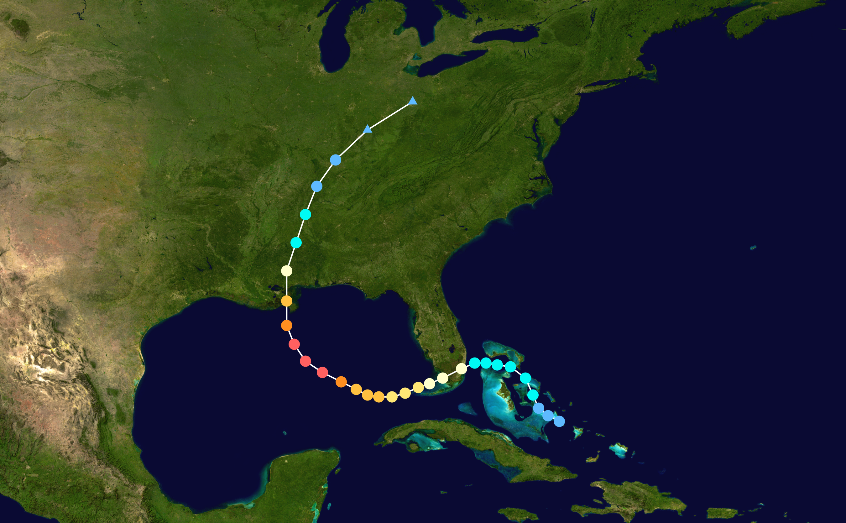
Case Study: Hurricane Katrina
Hurricane Katrina
- Formed 23rd August 2005 and dissipated 30th August 2005. It struck New Orleans on 29th August
- Highest wind speeds were 175 mph
- Lowest pressure 902 mbar
- Worst affected area was New Orleans
- Total confirmed deaths were 1,836; only 400 of these were outside New Orleans. This makes it deadliest US hurricane since 1928.
- Total damage $90.9 billion (2011 USD)
Why was hurricane Katrina so destructive?
- The 2005 Atlantic hurricane season was abnormally active, possibly as a link to Global Climate Change warming the Atlantic ocean increasing the number and intensity of storms
- Hurricane Katrina entered the Gulf of Mexico; the Gulf of Mexico is very warm water and is effectively like giving red bull to a hurricane. The intensity of the storm increased from a category 1 hurricane (which landed in Florida) to a category 3 hurricane when it landed in New Orleans. Obviously this is going to cause more damage
- The relief effort was poorly managed (more on this later), for an MDC of America’s stature and wealth the relief should have been much more efficiently
- New Orleans is on average between 1 and 2 feet below sea level with parts of it being 7 feet below. On average only 51% of the city is at or above sea level. The problem actually is that the levees constructed to keep the water out keep the water levels above the height of the city (see the diagram to compensate for my awful description…). This means it is very easily (and was very easily) flooded, the city just fills up like a bowl. http://en.wikipedia.org/wiki/File:New_Orleans_Levee_System.svg
- Louisiana is ranked 49th in the US states for Human Development. The poorer quality of housing and education could have contributed to the large destruction. The lower affluence of the region also means that many were left without transport out of the city when the evacuation order was given.
- The storm surge extended up to 6 miles inland in some areas. By 31st August 80% of New Orleans was under water with some areas 15 feet under.

How prepared was New Orleans?
- In 2001 FEMA identified the three biggest threats on life in the USA. 1.) A major hurricane hitting New Orleans 2.) A terrorist attack on New York 3.) A large earthquake in San Francisco. Partially as a result of this the engineer corps (responsible for maintaining New Orleans levees) investigated the cost to protect South East Louisiana but decided against it, as the recurrence of a category 5 hurricane in New Orleans was 1 in 500 years. Thus is wouldn’t be economically viable to protect New Orleans.
- A simulation named Hurricane Pam was actually conducted in July 2004, which predicted the damage and destruction that would ensue from a category three hurricane striking New Orleans. The simulation highlighted several key areas that needed to be addressed to minimise casualties if a hurricane were to hit New Orleans. This website is good to read up on the hurricane Pam simulation however bare in mind that since hurricane Katrina, the response to the simulation has come under a lot of criticism so the article may be biased; http://www.globalsecurity.org/security/ops/hurricane-pam.htm
- America has arguably the best emergency response team in the world, FEMA (Federal Emergency Management Association). However in this disaster it wasn’t up to scratch, why was that? Probably because George Bush put his lawyer mate Michael Brown in charge when he had no disaster management experience, but who’s pointing fingers?
- Hurricane Cindy probably saved thousands of lives in New Orleans. Residents of city had become complacent about the risk from hurricanes meaning that when Cindy struck on 5th July 2005 few people evacuated the resulting damage forced the largest blackout in New Orleans since 1965. This scared people meaning that when hurricane Katrina was forecast more people evacuated.
How did the Government Respond?
- On the 28th August Mayor Nagin ordered a mandatory evacuation of the city, however many refused to leave due to a lack of money or the belief that their properties offered decent safety. This illustrates the lack of education about the impacts hurricanes.
- A last resort was set up for those people who didn’t leave the city; the Louisiana Superdome was supplied with ready to eat meals and bottled water but individuals were told to bring as much food and blankets as possible.
- The collapse of communication infrastructure made it difficult to organise relief efforts to relieve the many-trapped citizens who were surviving on rooftops throughout the city. In some cases reporters were asked to assist authorities in providing information about unreachable areas. By September 4th a temporary communications hub had been erected
- Only two routes remained available open out of the city and one of these was only holding emergency traffic. Fortunately New Orleans airport was relatively unscathed and opened to humanitarian flights on the 30th August and commercial cargo flights on the 10th September. Passenger flights were resumed on 13th September.
- The initial refuge of Louisiana Superdome was deemed unsafe after several roof sections were compromised and the waterproof skin on the dome was ‘peeled’ off. The governor of Louisiana evacuated the remaining people inside the stadium to the Houston Astrodome on The 30th August.
- The police force has had mixed reactions following the hurricane, they clearly played a key role in the search for survivors and also helped to control looting however many officers had ditched the city with their patrol cars before the hurricane. One resident was told to “Go to hell, it’s every man for himself” when he asked a police officer for help. It also emerged that the New Orleans police department covered up the murder of two residents by fabricating a story of being fired upon and planting a gun on the dead after the police had killed them.
- The 31st August saw the announcement that the police were now focusing on trying to control looting and violence that was hampering relief efforts. Louisiana governor Kathleen Blanco also announced that 6,500 National Guard were on their way and that “they have M-16s and are locked and loaded. These troops know how to kill and I expect they will”.
- Bush has also been criticised by foreign by foreign leaders for not accepting aid or taking a long time to respond. Interestingly some nations who you wouldn’t expect offered aid, particularly Cuba. America hates Cuba, so it’s of little surprise that they rejected the aid. Our own John Prescott was brave enough to blame the disaster on the fact that America hadn’t been participating in Kyoto.
- Bush was also criticised as it was him who had appointed Michael Brown as leader of FEMA and it had been them who the majority of blame had fallen due to the slow and poor response.
- Bush was also accused of racism, but be careful how you use this point and how you word it.
So how does this link to SPEED?
- S – It was largely the poorer populations who were worst affected as they had no transport out of the city and were stranded.
- P – Bush went on to lose the congress to the Democrats (his opposition) in the 2006 mid-term elections. The governor of Louisiana also chose not to run for a return term.
- E – The shutdown of oil platforms and refineries in the Gulf of Mexico was enough to increase oil prices.
- E – Many people suffered from mosquito related diseases such as West Nile fever and other waterborne diseases such as cholera. Interestingly it’s been proposed that the best way for New Orleans to recover in the long term is to repair wetland areas that were damaged by the hurricane as this will vastly improve fishing outputs.
- D – New Orleans is known for blues, this is something else for them to sing about. It’s also been suggested that Bush didn’t act as efficiently/quickly due to the high percentage of black population in New Orleans.
Sorry that this was so long but it’s a huge subject and I’ve cut down loads, probably to the extent that it’s missing some vital stuff but else it’d be massive. There are also a lot of other links to SPEED but I just gave a couple for each point as you should be able to figure them out. I’ll put some pictures up later but I’m now off to play a gig. Cheers for reading!
Sunday, 13 March 2011
Temperate Climates
Cool Temperate Western Maritime Climates don't you just love 'em? Well if you don't then, unless you're planning on emigration, you need to get used to them.
So where are they found?
- Well between 40 and 60 degrees North/South constitutes a temperate climate
- And being on the Western edge of a continent constitutes a maritime climate
- What determines how far inland the climate extends is based upon the relief of the land
There are three types of rainfall: - Orographic Rainfall
- Convectional Rainfall
- Frontal Rainfall
So what other countries are remarkably lucky to share the same climate as the wondrous UK?
- South West New Zealand
- Chile, the Andes block the climate from extending any further within the country
- Canada, Vancouver - the Rockies block the climate from extending any further
- Western Europe, quite a few countries share our climate because the climate doesn't get blocked until the Alps
What does a Cool Temperate Western Maritime Climate mean?
- Weather is changeable with no marked seasonal differences
- Plenty of cloud and precipitation all year round
- Extremes of temperature are rare
- Low annual temperature range
- Fairly strong winds
- Warm summers
- Mild winters
- Maritime climates are unique as they are unusual to what we'd expect on similar lines of latitude. For example the UK are on a similar latitude to Moscow yet we experience a vastly different climate.
- The reason for this is due to the high specific heat capacity of water. Water takes longer to heat up and cool down than land, this means that summers are cooler than expected and winters are milder.
Any questions?
Subscribe to:
Posts (Atom)